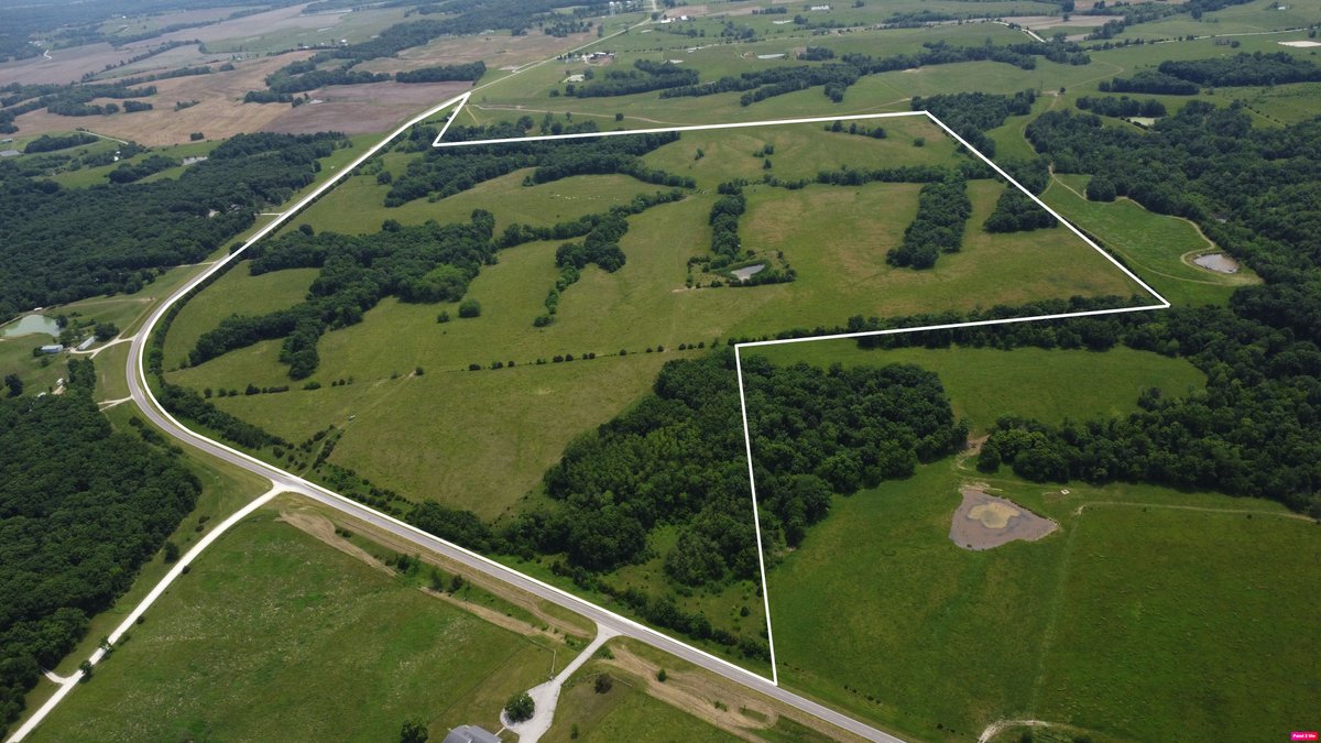
#1 • 215.01 Acres M/L
Part of Randolph County, MO ONLINE ONLY Land Auction - 215.01 Acres M/L (#18391) (timed auction by Peoples Company)
Location: Huntsville, MO
High bid $4,000.00
Status: PENDING APPROVAL
Mark your calendar for March 2nd at 9:00am CT when bidding opens on 215 acres m/l of well-maintained pasture in the heart of Mid-Missouri! This property offers an ideal opportunity to expand an existing cattle operation or establish a new livestock venture. The tract features gently rolling terrain with excellent access, including over half a mile of frontage along a paved state highway with multiple entrances. Bidding will close on March 12th at 2:00pm CT. The land has been lying idle since November, following the summer grazing season, and has been sustainably managed to prevent overgrazing. A centrally located pond provides a reliable water source, while rural water and electricity are available at the road. Additionally, several elevated sites offer scenic views and excellent potential for building a home or barn. The property is approximately 80 percent open, and the perimeter fence is in good shape. Some cross-fencing has been completed as well. Located just 10 minutes from Huntsville and 15 minutes from Thomas Hill Lake, this farm is conveniently situated for both agricultural production and outdoor recreation. Tracts of this size with highway frontage and utility access are increasingly rare. Contact Kurt Hollenberg for more information or to schedule a private showing. There will be a property showing on February 14th from 9:00am - 1:00pm. Legal Description Although the legal description references multiple tracts, the property is offered and will be conveyed as a single parcel Tract 1: Beginning at a point 9.50 chains West of the Northeast corner of the Southeast Quarter of the Northwest Quarter of Section 35, Township 55, Range 15, and run thence South 14.52 chains, thence South 53 % degrees West 3.28 chains, thence South 3.52 chains to half section line, thence West to Southwest corner of said Southeast Quarter of the Northwest Quarter, thence North to Northwest corner of said Southeast Quarter of the Northwest Quarter, thence East to place of beginning, and being the West part of the Southeast Quarter of the Northwest Quarter of Section 35, Township.55, Range 15, Randolph County, Missouri. EXCEPT that portion heretofore conveyed to State of Missouri for highway purposes, AND EXCEPT all that part thereof lying North of State Highway "C". Tract 2: The East Half of the Southeast Quarter of Section 34; and the West Half of the Southwest Quarter of Section 35; and all that part of the West Half of the Northeast Quarter of the Southwest Quarter of Section 35 which lies West of the county road; all in Township 55 North, Range 15 West of the Fifth Principal Meridian. ALSO, all that part of the East Half of the Southwest Quarter of the Northwest Quarter lying South and West of State Highway "C" in Section 35, Township 55, Range 15. All in Randolph County, Missouri. Tract 3: All of the East Half of the Northwest Quarter of Section 2, Township 54, Range 15 lying West of State Highway "C", AND ALSO the Southeast Quarter of the Southwest Quarter of Section 35, Township 55, Range 15 lying West of State Highway "C". All in Randolph County, Missouri. EXCEPT the coal and other minerals underlying said lands. AND EXCEPT that part thereof conveyed to the State of Missouri for State Highway purposes. Tract 4: The West Twenty-five (25) acres of that part of the West Half of the Northwest Quarter of Section 35, Township 55 North, Range 15 West of the Fifth Principal Meridian, Randolph County, Missouri, that lies South of the public road as it existed on June 13, 1931; EXCEPT the coal underlying said land; AND EXCEPT coal and right of way as conveyed by deed recorded in Book 37 at page 467 of the deed records of Randolph County, Missouri. AND EXCEPT that part deeded to the State of Missouri for highway purposes. ALSO EXCEPT all that part of the West 25 acres of that part of the West Half of the Northwest Quarter of Section 35, Township 55, Range 15 that lies South of the Old Public Road as it existed on June 13, 1931, and North of present State Highway Route "C"; AND EXCEPT that part thereof conveyed to State of Missouri for highway purposes by instrument recorded in Book 148 at page 173 deed records of Randolph County, Missouri; AND EXCEPT that part thereof acquired by the State of Missouri by Condemnation proceedings as shown by instrument recorded in the Recorder's Office of Randolph County, Missouri, on October 17, 1973, in Book 20M at page 161. Exact legal description to be taken from Title Commitment. Directions From Moberly, MO, take Hwy 24 West. 5 miles. Take a right on Hwy C, go North through Huntsville, MO, and keep heading on Highway C for about 6 miles to the property on the West side of the road. Improvements Improvements include boundary fencing and some cross fencing with a pond for watering cattle. Parcel Number: 03-7.0-35.0-0.0-000-006.000,03-8.0-34.0-0-000-008.000 School District: Randolph County School District General Area: Randolph County Net Taxes: $182.67 Water: Public water available on opposite side of Hwy C. Zoning: Agriculture